
As a method for limiting premature expansion, the Regional Plan establishes the Truckee Meadows Service Area (TMSA). The TMSA is the area within which one can expect the delivery of municipal services, either currently or within a 20-year timeframe. The TMSA is further defined by the following Regional Land Designations: Mixed Use Core, Tier 1 Land, Tier 2 Land, Tier 3 Land. Areas within Washoe County that are outside the TMSA are designated Rural Area (RA). The Regional Plan prioritizes development from the core outward. These Regional Land Designations are used as a tool to achieve our community’s desired regional form.
These Designations are described below, and to learn more, the Regional Form section of the Truckee Meadows Regional Plan can be found on pages 81 – 89 which can be accessed here: www.TMRPA.org/2024-Truckee-Meadows-Regional-Plan
Please pay specific attention to policies RF 3 and RF 5 on pages 85 and 86, respectively.
TMRPA staff presented the RDL module at the February 26, 2026 Regional Planning Commission Meeting. To view the slide deck and watch the presentation, click the buttons below. Additionally, the quiz is also available to test your knowledge of the Regional Land Designation module.
MIXED USE CORE: Area within the TMSA where the most intense development is expected to occur and is the highest priority for investment. Reflects jurisdictional master plan boundaries for mixed use, high density and intensity areas that are generally served by transit and have multi-modal connectivity. Public facilities and services are generally in place. Intensification in this Regional Land Designation is most desired and first in the development priority hierarchy.
TIER 1 LAND: Area within the TMSA where a moderate/varying range of development is expected and number two in the priority hierarchy for development. A variety of residential and non-residential uses exist in this area. A majority of the area within this Tier is already developed, or within close proximity to existing development. Public facilities and services are generally in place. This area is generally served by transit and/or has multi-modal connectivity.
TIER 2 LAND: Area within the TMSA where there is generally less dense development which occurs at suburban levels, with some higher density nodes, and third in the priority hierarchy for development. A variety of residential and non-residential uses exist in this area. Public facility and service provision is currently in place or is planned. There is a desire to have connectivity to Tier 1 Lands and Mixed Use Core area through multi-modal means.
TIER 3 LAND: Area that is generally on the periphery of the TMSA and contains low density development, is undeveloped, or contains significant development constraints. Development in this area is lowest on the priority hierarchy for lands within the TMSA. Public facility or service provision is generally not available or planned for.
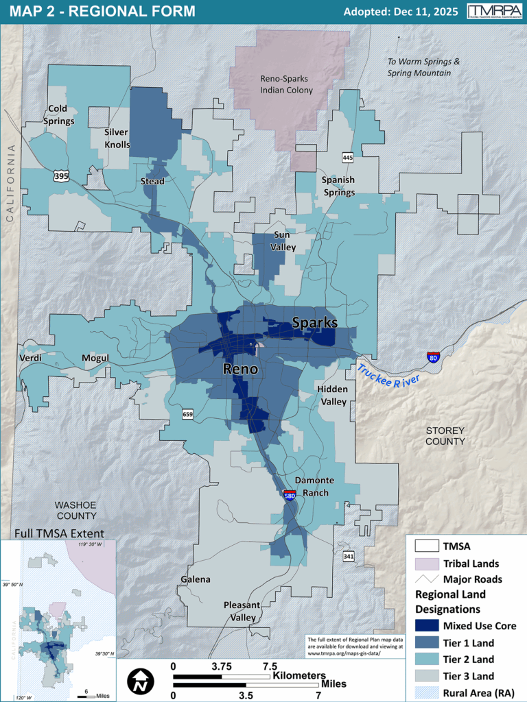
RURAL AREA (RA): All of the land subject to TMRPA jurisdiction that is outside of the TMSA. This area is restricted to very low density development, and generally consists of dispersed development and employment on large parcels of land. Ranches, agriculture, forestry, scattered residences and business or commercial services, and certain types of industrial and recreational uses not compatible with urban or suburban development characterize the RA. Development in this area is the lowest in the priority hierarchy. Public facilities and services are limited and may not be provided from the TMSA. The RA is not anticipated to absorb a significant share of the Region’s 20-year growth projection.
The Regional Plan recognizes that certain areas in the RA are unique and require different management strategies, thus the RA also contains three overlays – Rural Development Area (RDA), Resort Service Area (RSA), and Freestanding Communities. A brief description of each follows:
RURAL DEVELOPMENT AREA (RDA): Allows for the clustering of density in specific areas to allow for increased preservation of natural resources. This overlay allows for low density development that does not promote the expansion of the TMSA or the extension of certain public facilities or services from the TMSA to serve development of the area.
RESORT SERVICES AREA (RSA): Allows for the development of a resort destination in settings with significant natural amenities in identified areas. These areas are intended for primarily transient guests where the primary attraction is recreational facilities or activities.
FREESTANDING COMMUNITIES: Recognizes developed areas that have been in existence since before the adoption of the Region’s first Regional Plan. These areas are not contiguous to the TMSA and public services and facilities are not extended from the TMSA to serve them.
Finally, TMRPA’s jurisdiction includes all areas in the TMSA and Rural Area which comprises the bulk of the lands within Washoe County. However, any lands within the hydrographic basin of Lake Tahoe or within federally recognized tribal reservations are exempted from conformance review under the Regional Plan.